Open Up the Registers
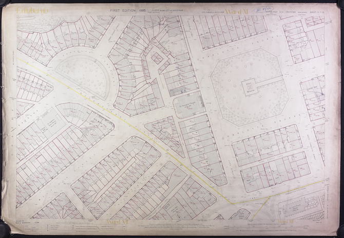
It is an odd state of affairs that it is easier to find out the ownership of land in 1915 than it is in 2018. The Finance Act of 1910 (Lloyd George’s famous People’s Budget”) proposed an increment levy on the increase in value of land. To establish a base-line of values, surveyors mapped out in intricate detail, the ownership, occupation, value and use of virtually all of Great Britain and Ireland, covering 99.7% of the land area of Scotland.
The map above shows the results for the west of Edinburgh around Charlotte Square.
In 2018, with modern technology such as digital mapping, satellite imagery, online technology and smartphones, we have yet to come close to what the Edwardians achieved with paper maps and ink.
Across the world, modern technology and integrated data management has delivered land informations systems that provide comprehensive data on land to citizens. From Scotland, for example, you can find out a wide range of information about land parcels anywhere in the US State of Montana. If you want the same data for Scotland, you will be frustrated at every turn, expend an inordinate amount of time and have to pay for it.
The question of Who Owns Scotland has been perennial one for decades. John McEwen had a go at answering it in 1979 and it was the focus of my first book published in 1996. In the early years of devolution, I tried to persuade the then Scottish Executive to open up land information to the public but there was little appetite. Since then, I made representations to Fergus Ewing and Parliament during the course of the Land Registration (Scotland) Act 2012 to persuade them to increase transparency and access to land information.
In a meeting with Fergus Ewing and the Keeper of the Registers of Scotland in December 2011, I made the case for this but the Minister could barely disguise his contempt for my suggestions and later, in the course of the passage of the Bill flatly rejected the idea that the public should have free access to land information (See col 962 8 Feb 2012 Official Report).
He also rejected proposals to reveal the beneficial owners of companies that own land although the Government were eventually persuaded to do so in the Land Reform (Scotland) Act 2016, the provisions of which are yet to come into force.
But this blog is not about beneficial ownership. It is about access to information that already exists but is difficult and costly to access. The recent history of attempts to open up access is dismal as the following examples make clear.
PASTMAP
Over the decades I have spent researching landownership, I have developed a range of methods and sources. Although the Register of Sasines and Land Register are the definitive sources, they can be impossible to use in certain circumstances, For example, if you want to know who owns a field at a junction of a country road in Fife, you won’t be able to do so from official sources since you need an address or a name of a person and even the map-based Land Register will often be unhelpful in such circumstances.
Key to success in such cases is to find out some information from other sources to enable interrogation of the Registers. One such source is a very helpful online map called Pastmap [http://pastmap.org.uk] which provides information on various elements of the historic environment. If there is a Scheduled Monument located on or near land whose ownership you wish to establish, then a link is provided to the legal documents that are registered in the Register of Sasines. These provide details of the ownership of the land at the time of scheduling.
In 2012, however, I noticed that Historic Scotland had redacted the ownership information. See the example (second page) of the Bonawe Iron Furnace Schedule before redaction and after redaction.
I wrote to Historic Scotland and asked them why the schedules were now being redacted. They replied that,
“Since the publication of the online schedule we have begun to redact the names and the addresses of legal owners from the scheduling documents given the perceived additional risks and sensitivities associated with publication of this information in such a readily and widely accessible format online.”
We are also considering removing legal ownership details from our scheduling certificates completely as part of an overall review of our scheduling documentation.”
These documents are recorded and made available to the public in the Register of Sasines (and made available for public inspection in the National Records of Scotland) with no redactions, so why conceal this information on Pastmap? What exactly are the “sensitivities” over this information? And why is Historic Scotland considering removing these details completely in future? Above all, if the Scottish Government is committed (as it claims it is) to transparency, why is it seeking to conceal this information from the one freely available source to the public?
Such questions remain unanswered.
SCOTLIS
Following a report in July 2015, John Swinney announced in October 2015 the establishment of SCOTLIS (Scottish Land Information Service), an online portal that would enable “citizens, communities, professionals and business to access comprehensive information about any piece of land or property in Scotland” The service was developed by Registers of Scotland and launched in November 2017. Here it is.
It is useless.
There is no map-search facility, there is no comprehensive information (solely landownership) and, as always, any information you do find, you will have to pay for. Contrast it with the online Montana service above. If you are a business, you can sign up as a business user and get access to an enhanced service. But by no stretch of the imagination is this a system allowing easy access to comprehensive information by the citizen. No wonder John Swinney’s successor issued no media release on the day of its launch.
OVERSEAS OWNERSHIP
On 1 March 2018, the Registers of Scotland published an Overseas Company Report and a Statistical Report on the overseas ownership of land in Scotland. Against growing demands for greater transparency in who owns land and property across the world, this is presumably Scotland’s contribution.
The report reveals the companies registered overseas that own land in Scotland. But this is the tip of the iceberg because it only takes account of land in the modern land register and not the older Sasines register. It doesn’t include any information on how much land is owned overseas (my own research shows that 750,000 acres of Scotland is owned in tax havens posing problems for law enforcement and tax authorities).
The Sunday Post published details of the findings on 11 March 2018.
And yet, the public are denied access to this data underlying the Overseas Company report because to obtain the report (see Information Sheet) will cost you an astonishing £1560 (the Statistical report is free to download). Even if you could afford this sum of money, if you wished further details of each of the records, you will need to buy this from Registers of Scotland. It will cost you £30 each and if you wish details of all 1700 companies, that comes to a cool £51,000.
Registers of Scotland claim that the data is being charged out on a cost-recovery basis (i.e. RoS only plans to recoup its costs from sale proceeds). But this merely emphasises why all of this data should be freely available. Were it to have been so over the past decade or so, all sorts of people would have been able to compile all sorts of reports and analysis within their own resources at no cost to the public purse and to the wider public good.
OPEN UP THE REGISTERS
The public deserve access to information about who owns Scotland. It’s time to end the secrecy and the costs and open up all information (environmental, planning, valuation, tenure, ownership) in an accessible manner which is free and easy to use by the citizen.
Over the coming months, I invite those with an interest to join me in campaigning for greater transparency and openness in land information.
I find Fergus Ewing’s attitude most reprehensible to the point of being a disgrace within the SNP. No wonder the modern presentation of the Cheviot, The Stag and The Black, Black Oil is still as relevant as the original 40 years ago. I watched Rob Gibson’S ( ex MSP) face during a performance of the show at Eden Court in the not too distant past and not a flicker of embarrassment or shame.
I wholeheartedly support your action and hereby volunteer to help. This land has been stolen in the past and remains stolen to this day. It is my contention that the so called owners are guilty of reset as they have bought stolen property. The land should be taken into public ownership and it uses and rents decided by the people of Scotland.
Count me in.
It is about time that we (The People) had greater transparency and openness about environmental, planning, valuation, tenure and land ownership which should be freely and easily accessible to anyone.
Andy,
Well done for keeping at this battle. I agree with every point that you make about the importance of making this information available free on demand.
What you suggest Andy is simple common sense and in the public interest.
The scottish ministers are in awe of the landlords, and carry out their every wish.
They have made available a fabulous pot of cash to the landed few for tree planting, bog expansion and farm subsidies, giving them even greater incentives to evict people off the land.
Great blog Andy – £30 search of land registries is certainly not something community groups can afford.
I would have dismissed this blog as an anti SNP Government blog if it had come from any other MSP than yourself. I appreciate the SNP have their faults but it is irritating in the least that they have not given this issue any more than lip service in the time they have been in power. Land ownership goes to the core of a Nations identity and economic welfare, and I take my hat of to you Andy for the years of work you have dedicated to this topic. I have read “The Poor had no Lawyers” as an introduction to this whole topic and was delighted that you were elected to Holyrood to be able to work on this. I am more than happy to volunteer to help get this out in to the public domain.
I agree James. I was an SNP member for 3 decades and was part of the their first Scottish Land Commission team in the 90s. I am still an ardent supporter of independence, but I got sickened by the attitudes of several senior members of the SNP towards real substantive land reform.
I agree with you Andy. The land is our country, our world. It is right that we should know who claims legal ownership over any particular piece.
Hi Andy
I wonder what your view of the current & potential role of companies which provide RoS reports is? Eg scotlandsearch and Millar&Bryce.
Thanks
They provide useful services to people and no doubt will continue to do so. There are other companies in this field who I think rip of customers. But for those who would like to undertake their own research, they too should be free to do so with no barriers of money put in their way.
thanks, seems fair to me.
Its gone past the time of public awareness on who owns Scotland. The late Shirley-Anne Hardy foreseen the time when the landlords would buy and sell us whenever they wished. It is sad that Fergus has no backbone where these thieves are concerned. Being denied the knowledge of who owns Scotland, land can change hands between an Arab Sheik to a Russian billionaire and be bounced around China or the highest bidder without our knowledge. This is a dollar too far!
I’m with you Andy
Ignoring the obvious transparency issues, surely the issue is one of efficiency as much as anything else? Ease of data gathering and access should be paramount. It must make life extremely frustrating for those agencies that are required to hold/update/audit these records. It should surely be a function of government to ensure that these processes are run in the most efficient manner possible? It could only be deliberate to set up such an awkward system of data management, as no competent person would set up something so difficult to access. Why would a deliberate obfuscation of this data occur? It can only be to benefit certain individuals or entities. It’s simply a waste of tax-payer funds to hold such information in such a poor format as the associated data management costs inevitably increases. It’s – at best – poor management.
Lack of information on land ownership is a stumbling block to all sorts of potentially useful work; it’s a practical as well as a political issue, and high time it was resolved.
I have conducted extensive research on Sasines in the past and they are, at least initially, almost incomprehensible to the man in the street. The current move to align descriptive land titles and what is fact on the ground with a cadastral map is proving just how inadequate the system is.
Having used both the Turkish and Bulgarian systems, neither hampered by a long history I find myself suspicious that the problem we have in Scotland is not a technical one but one of balance. the balance of advantage with the old system lies with the landowner and the few people or organisations in control of vast areas of our country have more to lose than anyone from a transparent easy to use system.
We should have an electronic system available online with free access to all. Why should who benefits from the ownership of a particular piece of land be a secret?
Good to hear La Lotta Continua and you are carrying on the good fight. If you had told me back in 1973 when I was working with John McGrath contributing on the land issue for ‘The Cheviot’ that we would still be in this position of ignorance as to the ownership of our land nearly 50 years later I would not have believed you. And the idea that we would have had a Scottish Parliament with successive non-Tory governments for some years and yet still be encountering active opposition in obtaining information and knowledge over private ownership, never mind an actual implemented programme of public ownership, would have been seen as totally absurd. Yet here we are, facing essentially that John McEwen came up against for his 1971 Acre-ocracy of Perthshire or his compilation for his tabulation of ownership in Scotland for the 1975 Red Paper or the wee study I did with Davie Ross in Calgacus 2 on ownership of the Argyll islands. Fergus Ewing really should hang his head in shame. ‘Who owns the Land?’ was the clarion call that ran through the Cheviot and which was taken up by radical voices and movements on both sides of the independence divide. and it found substantial and widespread support in a’ the airts’ o’ Scotland. It is the sort of fundamental issue on which the whole campaign for control of our own affairs in Scotland was fought. As well as being a debt that should long ago have been fulfilled it is also the essential knowledge on which the struggle to regain control of the land can be based and taken forward. Reflecting back on the validity of these old eternal rallying calls, your laudable work to date as well as this present call for support reinforces the validity of that other old slogan ‘ ‘Knowledge is Power’. So let’s get it and let’s use it. Happy to enlist in the foot soldier ranks.
Ray–hear hear! I could not agree more. And it’s not just Fergus Ewing who’s has been dragging heels.
I concur.
Can anybody tell me of any legitimate reasons why the beneficial owner of land in Scotland should not be available to the public. Land in Scotland is a finite resource and its ownership and use should be of concern to all people who live and work in Scotland as its misuse can affect many people’s lives. With land ownership should come responsibility and accountability to the local people and to the local environment. Land should not be used just to make profit or for other financial reasons by some nameless person living on the other side of the world who has, maybe never been to the land they own , it should be used for the benefit of the local people and the country. If owners of land knew that they would be identified in public records they may take more care in what they do or don’t do with the land.
This is a disgrace. Count me in.
Twenty years ago I was on the Council of the Royal Faculty of Procurators, one of the organisations of Glasgow solicitors, when we were asked to take part in the original Scotlis pilot project, and I volunteered to represent our members on it, after which I attended regular meetings over a year or so. The project included representatives of the Land Register of Scotland, Ordnance Survey and Glasgow City Council as well as myself and a guy from the RICS. Oddly, the Law Society of Scotland had decided not to be involved.
The Land Register people seemed in total good faith and had put a lot of work into the pilot. They had a computer link to New Brunswick and we spent time looking at how all land information, e.g. ownership, tax bands, planning status, mining information, flood risk etc, could be accessed via one portal, even with the then state of computers.
We understood that the Scottish project was running in tandem with the English one, which was backed by Geoff Hoon’s department.
The aim was to make it all available for free.
As the months went on the person from Glasgow Council proved very politely obstructive, bringing out reason after reason why the time wasn’t quite right, no doubt unconnected to the fact that the Council was then making in excess of £50,000 per annum from selling property enquiry certificates. There were also issues with the possible privatisation of Ordnance Survey.
Eventually I stopped going and a short while later the project quietly died.
Time for a ministerial reshuffle!
it doesn’t matter how you stir a pot of sharn
Ewan Kennedy’s very interesting informative comment made me think of the City of Edinburgh Council and the scandal of all the recent property speculators developments with the secret disposal of council publicly -owned land into private developers’ hands.
As it was in the beginning – the land issue is as important in the urban context as the rural.
Good on you. I have recently found it impossible to find details about the owners of a piece of land on Mull who are proposing a 50 year deal with a local community group.
Derek Crook
I suspect Local councils will continue to dispose of their assets for development as fast as they can (privately) with the subliminal support of the Scottish Government, in order to achieve their ambitious 50,000 new homes target over the next few years. Green spaces will disappear before your eyes, without a word of public consultation. Absolutely supportive of your stance Andy and agreed that land should fall back into public (Scottish only) ownership. Happy to help if I can.
The SNP’s actions on land reform have been feeble and tardy. If land is unclaimed after, say, two years then it should be deemed forfeit and ownership should revert to the Scottish Government. In such circumstances, I’m sure landowners would manage to find time to lodge their claims.
That’s true Colin, as I’ve frequently pointed to them. I agree that there should be a statutory default time on claim of ownership and if nobody claims the land then it should become res publica and sold off to a bona fide buyer when appropriate. I am an enthusiastic supporter and promulgator of AGR, but we can’t collect it, if we don’t know who the owners are http://www.slrg.scot
I used to pop into register house at jocks lodge to run searches if i had an hour or two spare while in edinburgh.
Last year they stopped that and made it appointment only.
I havent made it back , its a win win for secrecy
Regardless of peoples views on who should own it, I can’t see a good case for secrecy about land ownership. For example, ownership of shares in UK registered companies is published and access is free to all via Companies House. And if Montana, a pretty capitalist society is content to be open, why not Scotland?
And if the official answer is human rights, then God save us all from bureaucrats.
My local paper ( P&J) has a disturbing headline “Foreign buyers eyeing up estates in Scotland” According to Savills there is a growing trend of foreign interest in scottish land because it is outstanding value for money with approx 60% of scottish estates coming on to the market being bought by foreign buyers including Russian. Is this a trend that will see most of scottish land being owned by foreigners? It is vital that the beneficial owners of these estates are identified on public records so that they can be held accountable on how they manage their land. As an aside I believe that the Tulchan estate new beneficial owner is a Russian oligarch even though it is still owned by the company TESL ( see your post 23rd August 2016). If this is the case, how would this type of sale ( selling shares of a company that owns the estate) identify the beneficial owner in public land records?
The beneficial owner will have to be identified when the relevant provisions of the Land Reform (Scotland) Act 2016 come into force. How the property is sold will make no difference – there will have to be a declaration. Worth noting that with Tulchan, the beneficial owner of the company (person with significant control or PSC) is already identified in Company records and it remains the Litchfields. Not sure how the alleged Russian is involved.
Thanks Andy . The Russian came from a report in a paper I read a while ago about the sale of Tulchan but I/they could be wrong. However I still don’t understand how the land sale recording would work for overseas tax haven shell companies (about which you have reported many times in this blog) where it would be very difficult to find the true beneficial owner and how accountable would any declaration be from these sort of companies.
The new rules will only require owners to declare who the beneficial owner is. There is no way that this information can be verified, however since only law enforcement and HMRC can access company data held in tax havens.
Excellent blog. Reform has long been needed and I have been quietly wondering why the Scottish Government is so happy to sit on its hands and look powerless. I supported them to the hilt, but there appears to be a paralysis when tackling the big issues. The SNP are in POWER. I have yet to see proof that they know what that means
Have there been any advances since 2018?
What current politicians are interested in this?
Not really. See https://andywightman.scot/docs/SCOTLIS_2023.pdf